Trek to Mount Mat Cincang Peak
This trek will take you to the summit of Mount Mat Cincang in Langkawi. This is the second highest mountain in the Island after Gununga Raya and has an altitude of little over 700 meters. This is also the oldest rock formation in the whole of South East Asia and was formed some 550 million years ago.
The mountain is part of the UNESCO World Heritage Geopark. You will get to see some stunning rock formations on the way to the top. However, this is a challenging hike and is suitable for those who are fit and experienced trekkers. The trail after a point is very steep.
However, your rewards are also plenty. You will clearly see the change in foliage from the dense rainforest with giant trees at the lower mountain levels to the small trees, bushes and orchids towards the top. And of course plenty of flora & fauna on the way and the wonderful view of the island from the summit.
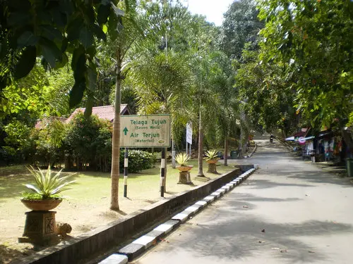
Service road from the base towards Seven Wells
This trek will take you through the famous
Seven Wells (Telaga Tujuh) Waterfall which you can see from the
Cable Car Ride. You will need to come to Pantai Kok area where there is a car parking space at the base. There are small stalls selling snacks & cold drinks. You can either start climbing the stairway that goes up from the right side of the stalls through the rainforest or take the steep service road that finally meets the stairway. The stairs lead to the Seven Wells waterfalls.
There are 638 steps to climb from the base to the waterfalls which is at an altitude of 480 meters. This climb itself can be quite tiring. Once you reach the falls, you will be able to see the seven pools from which the waterfalls has derived its name. Take a break here. You can sit on one of the several large but smooth rock formations and soak in the view of Burau Bay and Pantai Kok. There are natural rock slides that go into the water.
After resting for a while, cross the stream and you will find a few boards and also a trail that goes up through the forest. It's easy to find. A board here says the walking distance to the peak is 980 meters (while the peak itself is at an altitude of 701 meters above the sea level). It may sound easy, it is actually not so.
Follow the trail. Initially it isn't that difficult to trek. You will find the stream crossing the trail several times and there are narrow bridges to cross over the stream. The trail continues and after some time you will come to a point where there are signboards clearly warning you that the trail from here on is not easy. In fact it is an apt warning. If you are not a regular hiker, then think about turning back from this point. Otherwise, carry on.
The trail becomes little tricky to negotiate from here. You should wear comfortable but sturdy hiking shoes, preferably long cotton trousers, a cotton T-shirt, a cap and carry with you lots of drinking water. The trail now becomes quite narrow. Go around a cliff and you will reach an area that looks like a dry ravine full of loose rocks. Cross over and keep moving up. From here the trail becomes very steep.
You will find ropes leading all the way to the summit. The rope support is very useful as the trail is not only quite steep, during the rainy season, it can be quite slippery as well at several stretches.
After having crossed a wall of rocks, you will see that the dense rainforest is being replaced by bushes, smaller trees and orchids, and the forest is thinning out. Continue hiking and you will eventually reach the summit. There is a board there which says "Gunung Mat Cincang (701 M)".
Well, you should now be proud that you made it to the top of Mount Mat Cincang, the second highest peak in Langkawi which was born 550 million years back.
View from Mount Mat Cincang Peak
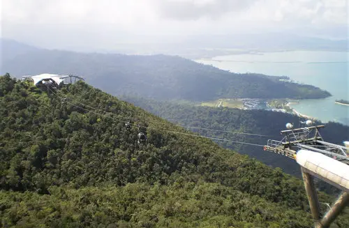
It usually takes about 3 hours from the base to the peak. An experienced trekker can make it in a shorter time. Budget another 2 hours for the descent. While at the peak, look around. On a clear day you can see wonderful panoramic view of the island and the sea, although the view at some places is obstructed by the bushes. You can see the cable cars plying, the Telaga Harbor below and even large part of Pantai Kok area.
On your way back, stop at the
Seven Wells Waterfalls to take a break. You can even plan to take a quick bath in a pool and freshen up. And once you reach the base, don't miss out on the fresh coconut water sold at the stalls.
Best time for the trek
The best time to take this trek is during the dry season (November to March). A gentle breeze keeps flowing from North East and the average temperature stays around 32 Degree Celsius. During the rainy season (June to October), it can rain very heavily and the trek may not be suitable at all.
There is a narrow trail at the top to explore even the summit area. If it is cloudy then do not explore that part as it can be dangerous. There are hardly any protections on the sides. In fact you should strictly stay on the marked trail all along the trek. There has been several cases of people getting lost for days and even fatal accidents on this trek mostly due to negligence on part of the hikers.
Guided Trek
There is a guided trek package that is offered by the Cable Car Operators to trek up to the top station in Mat Cingcang. It's known as Skytrail Trek which starts from the Cable Car base station. This trek is comparatively more comfortable. Check out
Skytrail Trek for details.
While you can yourself venture out and take the trek described on this page, it is advisable that you take a guided trek from one of the well known nature tour operators. This will help you know about the various flora and fauna that you encounter on the way and also assist you to take the right decisions at the right time.
One of the well known operators in Langkawi is JungleWalla who organizes this trek on request. Rimbawi Geo Discovery also provides nature guides for this hike.
Check out
Top Nature Tour Operators to get information about them, their offerings and contacts for further information and booking.
However, if you decide to trek by yourself, you are supposed to register at the small visitors center at the base (near the car park). It is also possible to get a guide from there, but may not be always available. You can reach the base area by taxi or rental car/bike. It's located in Pantai Kok area and at the end of the road Jalan Telaga Tujuh.
Map location of Seven Wells Waterfall
Alternative trek to Mat Cincang
While the above is the trek that takes you to the real peak of Mat Cingcang, there is an alternative trek that you can take from the base station of the cable cars at Oriental Village. The trail known as SkyTrail goes up the Mat Cingcang mountain from the other side, through the rain forest and all the way to the top cable car station (you can also terminate your trek at the intermediate station).
Once you reach the top, you can also trek for another 10 minutes and reach the SkyBridge. While coming down you can take the cable car. Read:
SkyTrail trek for complete details.
Related Articles
|
Visitors' Reviews/Comments
Licia Biffi (September 2018)
Hello, In December I'll be in Langkawi on a cruise. I would like to make the trek to reach the summit of Gunung Mat Cincang and to cross the Sky Bridge. These are my questions:
1) If you do a trek can you reach the bridge or is it possible only if you take the Cable Car?
2) If you do a trek can you come back to the Oriental Village with the Cable Car?
3) Is there dangerous animals such as snakes, venom spiders, etc.?
I wait for your reply as soon as possible. Thank you.
Raj (langkawi-insight.com) September 2018
Hi, if you take the trek route that goes through Seven Wells Waterfall all the way to the peak of Mat Cingcang (as described on my site), you can't get to the Skybridge. If you take the SkyTrail instead which starts from Oriental Village (at the cable car base station), you can hike up to the top station and a 10-minute trail from there leads to the SkyBridge (alternatively you can take the Skylift from the top station). If you take the SkyTrail (which is offered as a guided tour), you can come down by cable car. Venomous snakes etc have not been reported.
Lur (January 2016)
Dear Raj, My name is Lur. Thank you for posting such nice articles about Langkawi, really helpfull. I am going to visit Langkawi and spend a week there. Would love to do trekking, but still not sure whether needing a guide or not. I read your article about Trekking to Mat Cincang, it said that the track bit challenging rather than Gunung Raya. Is it safe to get to the top without a guide?. Since going to top to Gunung Raya is possible by driving car/motorbike, so i plan to skip trekking to Gunung Raya. Do you think my plans are reasonable? Thank you, looking forward to your answer.
Raj (langkawi-insight.com) January 2016
Hi, you can trek to the peak of Mat Cincang without a guide. However a guide is recommended if you are not a regular trekker. A guide can also help with information about the flora & fauna as you trek.
|